
Against metropolitan dispersion
Against metropolitan dispersion: a multitude of recognisable situations
Ph.D. in Architecture. Theory and Design.
Unrecognisable city
The metropolitan city is diffused, vast, fragmented and scattered, and leads to the loss of its perimeters and recognisability. In cognitive psychology we encounter countless affinities between mental maps and real maps. Just think of the following keywords, derived and condensed from cognitive theories: “borders, paths, junctions, landmarks and districts”(Costa 2009, p. 15 -20). The city’s boundaries are lost in countless in-between spaces, that often aren’t re-optimized through its most typical feature: the transit.
Mental maps and real maps: affinities
Cognitive maps are helpful instruments to help the user in organizing itineraries in a city quadrant, through the mental simplification of streets, parks and interest points that are summarized by the brain to remind them better and positioning them throughout a mental city plan, in fact «just as a real map is never the same as the territory it represents, seeing as a map is partially abstract, a mental map is a re-elaboration of reality, and it’s often distorted and incomplete […]. Paths are common spaces for transit such as streets, curbs, promenades, pathways. Borders act as boundaries or delimitations, and as such, in our minds they isolate space. Districts are spatial units which are physically or psychologically homogeneous. […] For example, a university’s campus or a hospital area delimit a territory with a specific function. Junctions are where paths, borders and districts cross. We have junctions where main streets meet, or where they end. Junctions are intersections, rotaries, tollbooths, street lamps, and so on. Landmarks are especially prominent elements, in the physical or psychological sense; they are points of reference. They’re usually highly visible, and very busy locations» (Costa 2009).
Spatial organization
As noted by M. Costa (2009), the organization of mental space «is extremely “self-centered”, that is to say, we think that spaces we are familiar with, and experience directly, are bigger». Elaborating and summarizing the concepts from the same author and the studies of Goldwurm G. (1987), we can state that , the brain is generally prone to simplify the space of the context surrounding a person; that cognitive strategy helps the user to recognise faster a certain spatial habitat; some examples may be the unconscious, cognitive straightening of streets, that are generally curved in real life (Costa, 2009; Goldwum, 1987). The spatial organization by users is generally derived from a summary of different perceptions, in fact «we can define psychological territoriality as a person’s or a group’s collection of behaviours and cognitions, based on the perception of ownership over a physical space» (Costa 2009). We may deduce that hat our subconscious is grouping areas through a ‘psychological territoriality’ as the spaces we are accustomed to know, our routine itineraries or the areas that are coming from our lived memory; our brain is synthetically summarizing all of those information – from our sight, emotions and all other senses – into his own mental map.
Architects and planners must aim towards a simplification of the everyday’s maps, to make them readable and easy to understand by all users; the most common “good practice” example is a subway map. It is easy to say that those maps are really comprehensible and clear; the user/viewer can immediately understand which is is place inside the system and how to get from a point to another. This is possible thanks to an extreme simplification of roads, itineraries and above all distances; in fact the underground map does not represent reality but “a” reality that allows the user to obtain orienting information fast and it allows to work on the data shown in a very effective way to reach the location desired. If the map was the real transposition of reality it would be absolutely unreadable, with way too much information that would create more confusion than clearness; in a metropolitan map – in a mental map – lines are shortened and straightened, colored and integrated with (universal) infographics to obtain the easiest and more comprensible drawing possible, with the aim to be intelligible by all commuters (Goldwurm 1987; Costa, 2009). The map doesn’t follow exactly the location of actual landmarks; yet, it works perfectly: this same concept of simplification should be applied, in the architectural and urban sense, to the city.

Existing problems
Nowadays the dimensioning of passages derives from studies on foot-traffic flux and from planning standards which have been considered the “rule of good building” for decades. However, studies (Goldwurm 1987) conducted on pedestrians’ behaviour show other interesting elements to consider. This body of work has verified that simple spaces are less alluring than spaces visibly more complex, a complexity obtained through a diversified use of colour, of messages, with the differentiation of spaces and with their specification. To this end, it can be interesting to signal with appropriate signs along the path the presence of particularly interesting spaces, «so that pedestrians are encouraged to reach them more quickly» (Goldwurm 1987). Pushing towards either too much geometry or too much winding in the city’s paths has both advantages and disadvantages. It’s surely useful to hybridise the two planning strategies to obtain results that are in an equilibrium with the existing city and most importantly with the ones who do and will use it: its inhabitants. The designers’ big-scale interventions on the city should aim at a smart variation in strategies. The planner has to deal with conflicting contradictions such as isolation and monotony, overcrowding, the excess of inhibitions and excitements – that is to say, with small-scale or big-scale stressing factors.
Dislocation: a new spatial organization
As S. Crotti states (2000), urban dislocation is an interval, a glitch, a difference between two separated areas or – according to the topics expressed – is a location between the city and the suburbs, or between an urban fabric and the natural environment; «dislocation is first configured according to the concept of limit, then it appears as an interval, and finally its configuration becomes a sequence following spatial dynamism» (Crotti 2000, p. 16). The designer should work exactly on this, overcoming the disjunctions, in order to make the serial repetition of buildings accessible and less oppressive, and to avoid the scattering of the human being in the city’s orientation.
For example, Lissitzky’s horizontal skyscrapers embed architectural signs that mutate an environment’s scale and conjure the symbolic meaningfulness of access – in which survives the meaning of urban limit – but on a different directrix. The architect reverses the point of view, making the volumes visible and crossable. He makes them perfectly recognizable in the urban fabric.
Even though the irregularity of a urban fabric causes more difficulty in orientate oneself, this doesn’t mean that said environment is perceived as less alluring. To the contrary: a geometrical, regular street network is perceived as monotonous and not very stimulating, whereas what makes historical centres so alluring is precisely the irregularity of their streets, which induces in the visitor a desire to explore.

The extremely regular and predictable design of street networks’ contributes to the squalor of the suburbs. The town planner must work on this predictability, to solve the problems of a city which is becoming more and more complex and vast, and which should preserve its recognizability as much as possible.
The recognizable city
Whitman said: « […] I contradict myself, (I am large, I contain multitudes)» (Whitman, 1855). These are the same multitudes of the contemporary city, vast and always in contradiction with itself. The architect’s task is to overcome this diversity and combine it coherently with the urban context; to engender not dispersion, but spatial multitudes that can be emotionally circumscribed.
It’s possible to find effective solutions for the contemporary city’s project: it should solve the spatial problems to make our cities liveable, and it should eliminate the discontinuity between the cities and the city itself (dislocation). It’s imperative to pay attention to perceptive/relational issues. A human being should no longer live in anonymous and dull locations but in environments that preserve their own history. In this way, it becomes possible to recognize and identify with them, and find in them both the moment for privacy and the one for relationship. Man should be put into a position to control the environment, not to “feel a sense of helplessness or loss, swept over by many stimuli without hierarchical meaning” (Goldwurm 1987).

This cannot emerge only from the physical configuration of an environment, even if it respects the psycho-physiological necessities of man (quality of life). The plan must start from a historical reality, which in every city is made by its actual inhabitants. Their lived experience is the starting point of planning a transformation, even with their direct participation. In the Smart City of Curitiba (Brazil) the transport system is the solution that aims to adapt the road network to people, not vice versa. To reduce traffic and air pollution, the administration decided to design the city so that people did not feel the need to use cars, creating an infrastructure network of exclusives arteries dedicated to incoming cars, outgoing cars and public transport. The bus lines are classified according to the type of transport and not the route: “express” and “slow”, to travel within the neighborhoods. A bus system working as a subway increases the urban livability, the revaluation of the historic center and pedestrianise huge parts of the city (Bulu, 2011). The social sustainability of this case study is given by “urban development in relation to man” through the participation of citizens, who are again “oriented” within the urban fabric.
Metropolitan Simplification
The hybridization of passages and various architectures is certainly a good starting point to create a “cognitive city”, always able to reveal itself to the user. Junctions, points, and networks, already present in our cities as linking spaces (horizontal and vertical), should become main landmarks. They should be always different and recognizable. Districts shouldn’t be closed enclaves; they should be inspired by Portzamparc’s concept of îlot ouvert, to guarantee the permeability of perimeters for pedestrians during passage on a multidirectional level (public/semi-public), with the aim to connect the most variegated types of users of the city. When dealing with existing street grids, orthogonal and rectilinear, a possible solution can be to embed various landmarks like underground exits, junctions, sculptures and urban lanterns, so that it’s possible to perceive a sequence of perfectly recognizable architectural situations.
In the vastness of metropolitan “urban situations”, we should embed a multitude of new places (even very little, like architectural gestures) which would intertwine with the urban fabric, and give it value and universal recognizability.
Acknowledgements
This text is an extract from the outcomes of the Ph.D. Summer School “City & Cognition”, held in EPFL, Lausanne, June 2016.
English proofreader: Clelia Maria Dri
Bibliography
Costa M. 2009, Psicologia ambientale e architettonica. Come l’ambiente e l’architettura influenzano la mente e il comportamento, Franco Angeli, Milan
Crotti S. 2000, Figure architettoniche: soglia, Unicopoli, Milan
Goldwurm G. et. al. 1987, Psychiatric Operative Unit 37 of Lumbardy, La città sotterranea nell’area metropolitana. Atti del convegno, proceedings, Milan
Bulu M., 2011, City Competitiveness and Improving Urban Subsystems: Technologies and Applications, IGI Global, USA
Images
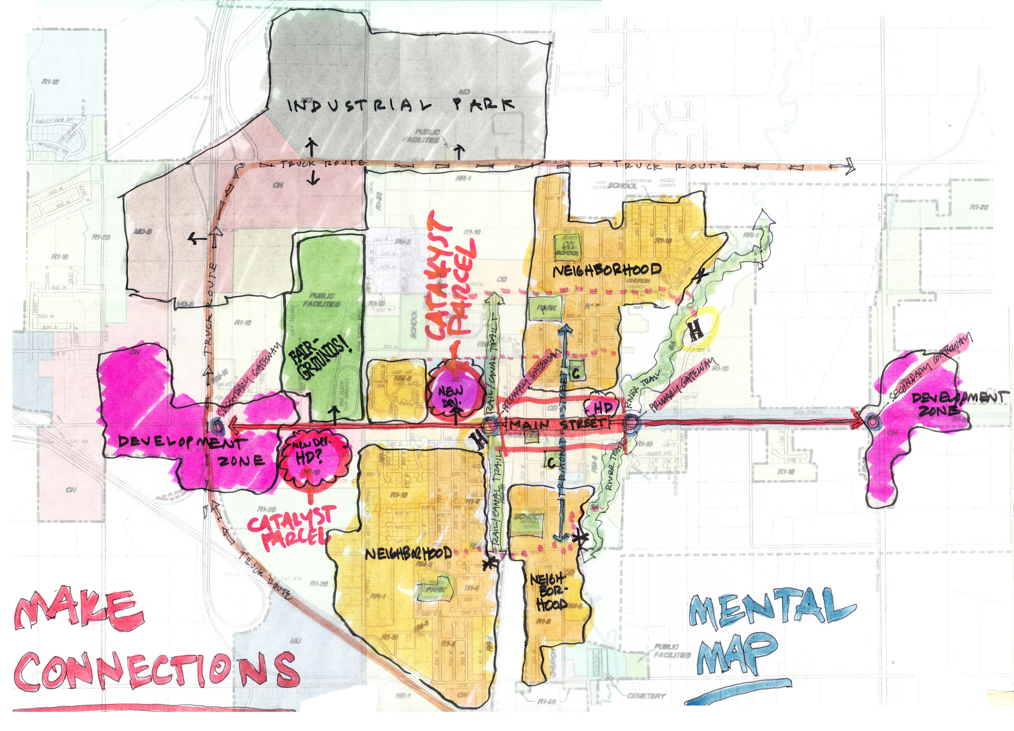
cover: Mental Map, Tremonton SDAT, Author: wfeiden, https://www.flickr.com/photos/wfeiden/9574374785, Attribution-ShareAlike 2.0 Generic (CC BY-SA 2.0).
fig.1: Map of the New York City Subway as of January 2017, Author: CountZ, Jake Berman, maps.complutense.org, https://commons.wikimedia.org/wiki/File:NYC_subway-4D.svg#file, Creative Commons Attribution-Share Alike 3.0 Unported license.
fig.2: Map of the Downtown Pedway System, Halifax, Nova Scotia. Drawn in CorelDraw using available mapping and observation, Author: Verne Equinox, https://commons.wikimedia.org/wiki/File:HalifaxPedwaySystemWeb.svg, Creative Commons Attribution-Share Alike 3.0 Unported license.
fig.3: Curitiba (Brazil): City bus system: – express bus routes (linhas expresso biarticulado) and “direct” routes (linhas direta), 10/2005, Author: Maximilian Dörrbecker, https://commons.wikimedia.org/wiki/File:Curitiba_PublicTransport.png, Creative Commons Attribution-Share Alike 3.0 Unported license.


