A dimension of landscape
Urban planning by Le Corbusier: infrastructure, contemplation, and poetics
Ph.D. in Architecture, Theory and Design, La Sapienza
Introduction
On the topic of Landscape, in any form, certain projects by Le Corbusier (LC) may be said to have unquestionably maintained a sense of both development and continuity with the modern era.
Projects such as the Rio de Janeiro and Algiers ones prove that certain concepts LC engaged with remain valid to this day and that current approaches to urban planning still rely on his same composition dynamics. Landscape may be natural, urban, industrial, etcetera; its importance is crucial in the process of architectural composition, whether on a large or small scale. LC’s writings are a source of instruction on how to directly confront landscape and enhance it through design that is mindful of urban context. An intimate poetic of landscape contemplation arises from his work, as well as a specific positioning of his constructions (and infrastructures) towards the best possible spot for observing the natural and urban context, so that it may pervade his residential buildings and thus be admired. At the same time, LC morphs landscape into a dynamic set for vehicle routes and itineraries, where the point of observation is endlessly shifting.
Several of LC’s ideas continue to live on in the present, namely his principles for the creation of “urban condensers”, various examples of layered functions, and the idea of a diverse typology of roads as a means of improving both a neighbourhood’s outer perception, as well as its living conditions, without forcing discontinuities.

Unity of Landscape
“Unity of landscape”as stated by L. F. Di Francesco (2015p.3)«is defined by those artificial compositions that can glorify the presence of nature […]. Landscape is turned into an element of composition through modification in the dynamic point of observation, which runs along the road structure. Visual perception of motion is determined by a variation in the point of observation, a rapid succession of scenery, and a loss of the limits of vision itself». With this background it is possible to reconnect our remarks to a few thoughts of the “Maestro”. LC thus comments a photograph depicting a Roman aqueduct in an urban context:
«Vestige Romain. Cet aqueduc, hors de l’échelle des maisons, détruira l’harmonie du site? Mais non! L’aqueduc a fait le site!» (Le Corbusier, 1933 pp. 119 – 120)
[Roman vestige. In comparison to the scale of nearby houses, will this aqueduct destroy the harmony of the site? But no! The aqueduct makes the site!]
Such is a key concept for successfully understanding the Rio and Algiers projects. Construction itself is woven into the landscape, proclaiming its very existence. This claim represents the red thread connecting all urban planning experiments hereby taken into consideration.
Rio De Janeiro – Contemplation on Perspective
After his 1929 trip to Brazil and a conference held in Rio de Janeiro, LC is entrusted with a series of ideas by the local administration. Struck by the land’s orography and decay in the favelas, he begins to outline a project on a local scale, intent on devising solutions and restoring the city’s poorest areas by infiltrating and integrating with the natural landscape: «the resulting drawing reveals a […]ribbon-like building, [employing]a method reminiscent of the one used for Roman aqueducts[…]Landscape therefore becomes visible when up against large-scale architecture»(F.di Francesco, 2015 p. 3). It is not just landscape tout court, however. Even the most intimate landscape is made manifest in his architecture, as can be seen in two other sketches, depicting a man seated alongside the Rio bay and, later, that same man seated inside a house(Le Corbusier, 1933 p. 58),admiring the same view: «the entire landscape enters the room[…].Nature thus becomes a fourth wall to the room. […] Landscape is made by structuring those architectural devices which render it “visible”, […]through the representation of the architecture’s presence itself» (F.di Francesco, 2015 p. 4).

Large-scale Section – Infrastructure as a Solution
There are countless amounts of sketches by LC dating prior to his final dispositions for Rio. Some include very large-scale studies he used to analyse target areas, making comparisons and identifying landscape and geographic diversity.
For example, LC juxtaposes two megacities: New York City, which he calls a “pathetic paradox” for its lack of space and therefore of an opportunity for “landscape-centred” initiative, and Buenos Aires, where he identifies a space “designated for a new city”. He compares the North and South of the world, perhaps to prove that the South – where there is greater urban decay – is better suited for his projects. Other sketches display two sections operating a transverse cut through the whole of Latin America. As a matter of fact, there is an evident succession of geographic areas: the Pacific, the Andes, the Pampas, and “the fateful place of exchange”. Sketches then depict the cities of Buenos Aires and Rio de Janeiro, illustrating the lack of space in the former, while showcasing the latter’s viable space – on the water – for the construction and support of a new building, using underwater rocks at the Rio de la Plata estuary. These preliminary sketches already provide a sense of how landscape both is and becomes a multipurpose infrastructure. Such a concept remains topical in analysing design issues in contemporary architecture and urban planning. At this point, it is undeniable that LC’s reflections still hold true to this day.

Multipurpose infrastructure is born from the integration of functions and services inside a single construction, whose design and placement within the landscape is, according to LC, meant to redevelop specific areas and determine their renewal.In his project, landscape does not amount to a geographic and natural backdrop, rather it is the construction itself who is woven into the landscape and leads the eye to its contemplation.Ribbon-like megastructures, as drawn by the architect, split the city into new sectors, which are re-urbanised, albeit schematically, through a thick mesh of roads and neighbourhoods. As such, they replace the decay of neighbouring areas, while the superstructure is always visibly propped up against both the water and the mountains. The structure itself integrates a road on its roof and continuous housing below it. It ultimately culminates into a voluminous complex on a cliff by the sea (the trade centre). All such elements are expanded upon in greater detail in the Algiers project.
Algiers
The total projects dedicated to Algiers (Plan Obus) are seven and can be divided into a first general project and six smaller ones.

During his travels to Algiers, LC was struck by the natural landscape, which was undoubtedly suited to the ideas he had already experimented with in Rio. He was also impressed by the local culture, city life, and the Casba in particular. In his integration project, the latter features as a focal point to which LC never denies connection and he considers it crucial in preserving local customs and social aggregation.The peculiarity of the Algiers projects lies in their settlement pattern. In this sense, LC creates a system to integrate his masterplan with the existing main roads. The immediate intent to hybridise and interconnect his system with a larger one is visible in his sketches: LC wanted to create a “settlement loop”that would lead to greater exchange between areas and inhabitants. He intended to counter difficulties in reaching the city centre and the harbour on existing urban routes, partly due to traffic congestion on the latter.

Hence, a further key word for LC may be surmised: Circulation. As a matter of fact, “circulation’’ is everything in this project and in itself the solution to a great number of issues within the city. It is immediately evident how each building designed by Le Corbusier is also a road, a call back to the infrastructure of the Roman aqueduct. Therefore, the (new) centre may be reached from any corner of the city, either by car or on foot. The centre itself is represented by the enormous “H” building positioned at the harbour. The building is none other than an “urban condenser”: it concentrates a variety of functions (including landscape contemplation) and signals both the beginning and end of pedestrian walkways and vehicle routes. The Algiers projects stand as a great experiment precisely in dealing with issues that affect contemporary cities: lack of space, traffic congestion, difficulties in interconnection. Of course, present demands have changed, taking on different directions such as more attention to pollution, recycling, and so on. LC’s experiments continue to be useful as guidelines for meeting contemporary demands in planning.

Continuity and Development
It is at this point easy to relate what has been discussed and described so far to actual contemporary architectures and projects. The key words gathered from the previous projects are layering, condensation, integration, ground enhancement, adaptation to geomorphology, and urban hybridisation. So, what is a contemporary city like? Cities of today are fragmented and the whole urban system possesses a variable and unstable density, as well as an undefined and shifting geometry.Present demands regarding ground use depend on a variety of factors, such as a lack in urban space, a need to expand portions of the city and renovate existing buildings, renegotiation of spaces, and urban renewal of decayed areas. A list of considerations which had already been touched upon by Le Corbusier. Infrastructure becomes landscape.

Examples like Copenhagen’s Loop city rehash the same principles of interconnection seen in the Algiers plan: BIG’s project involves not just the desire to reconnect the road system within a continuous cycle, but also that of creating cycles for water purification, waste management, etcetera. New York’s famous High-Line draws upon the same concepts as LC’s in regards to Roman aqueducts. Albeit touching on a single aspect (the regeneration of urban greenery), the infrastructure “makes the site” here as well and creates new urban layering, providing the city with new public space. Through such lens, it is easy to apply Le Corbusier’s concepts (as hereby examined) to a wide variety of contemporary architectures and projects. Some, such as Norway’s Rolling City (Jagnefalt Milton), become actual challenges in hypothetically going beyond the ideas presented so far, overturning concepts of hybridisation of landscape and architecture as they have been examined here.
When looking at Jagnefalt Milton’s project a question arises: what if future cities were to move within the landscape?
Bibliography
Le corbusier 1933, La Ville Radieuse. Éditions Vincent, Fréal & C.le. Paris
Le Corbusier 2012,Visions d’Alger, Editions De La Villette, Paris
Le Corbusier 2001, La Ciudad del Futuro, Ediciones Infinito; Translation edition
Falconi Di Francesco L. 2018, Paesaggi Urbani – Le Corbusier E L’unità Paesaggistica, Università Degli Studi Di Teramo, Master Universitario (Stmid), http://www.lucafalconi.it/wp-content/uploads/2010/11/ADGP010.pdf
Images
cover: Plan Obus, Algeri, Autohr’s Artwork.
fig. 1: Tor Lindstrand, Life Without Le Corbusier (Chandigarh), Caricata il 10 novembre 2015, https://www.flickr.com/photos/international-festival/22908683892, Attribution-ShareAlike 2.0 Generic (CC BY-SA 2.0).
fig. 2: Tor Lindstrand, Life Without Le Corbusier (Chandigarh), Caricata il 10 novembre 2015,https://www.flickr.com/photos/international-festival/22503814578/in/photostream/, Attribution-ShareAlike 2.0 Generic (CC BY-SA 2.0).
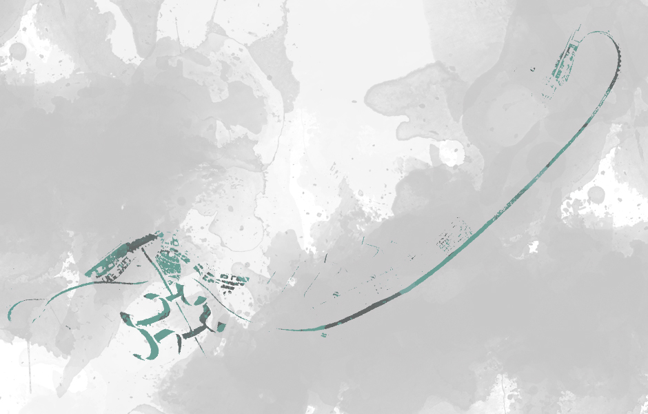
fig. 3: The 1933 rendering of Plan Obus for Algiers demonstrates Le Corbusier’s superimposition of modern forms: the long arching roadway that includes housing — his viaduct city — connecting central Algiers to its suburbs and the curvilinear complex of housing in the heights that accesses the waterfront business district via an elevated highway bypassing the Casbah. https://bidoun.org/articles/
fig. 4: Plan Obus model, with viaduct bypassing the Muslim quarter to connect European suburbs with business centre. Image source: https://publishing.cdlib.org/
fig. 5: Apartments at Fort l’Empereur were a formative precursor to Le Corbusier’s designs for the Unité d’Habitation. Image source: http://3.bp.blogspot.com/_
fig.6: Le Corbusier, sketch of a proposal for Rio de Janeiro, 1929 (Le Corbusier 1964: 225). in https://repository.up.ac.za/
fig.7: Le Corbusier’s sketch of a man admiring the view in Rio de Janeiro. The caption: “The whole sea-land- scape enters your room” (Le Corbusier and De Pierrefeu 1948: 87). in https://repository.up.ac.za/